February 26, 2009

dong lakorn (198 km): 7-feb-2009

route from lum sai (#3312-#4009-#2008) to bang sang. the tricky bit is the hair pin turn you need to make after the railroad bridge (thanks to pa somkate & khun tee from the nongchok bike club for the info). then up #3076 past sri chula (road's not so hot and a bit too much traffic for my liking).

this time went into the ancient city site (but ran out of batteries for my camera so only got a few pictures). nothing really outstanding but once you ride around you can feel how big the site actually was. the old city walls were kind of massive kind. worth the trip. GPS ate 1st 40km.


View Larger Map

From bike rides

dong lakorn (194 km): 14-feb-2009

the ride started out quite slow, very thick fog. took me almost 2 hours just to go 30 odd km up khlong 8--then figured out i could take off my glasses ;-) this route was up along the #305 highway to nakorn nayok intersection then down #3076 to dong lakorn. in the afternoon it was hot enough to make the grease run out of my hubs (and it's not even summer yet). ran out of daylight on the way back & had to hop a taxi.

dong lakorn is rather bigger than i expected, took me almost an hour to ride around the "dong" and i skipped plenty of side roads (although some were more mountain bike trails than "roads"). this time through i took plenty of photos.


View Larger Map


From bike rides

February 24, 2009

almost chet kot (215km): 21-feb-2009

i've been bombing around the ban cha om, grok e-dok, khaeng khoi area over the last year or so and i always wanted to see the "famous" chet kot waterfall--famous in that it was once written up in the bangkok post. after re-reading the article and pouring over google earth i finally found a route there that didn't require going up to thap khwang district first (there are only a couple of small signs pointing the way on the main road and pretty much no signage once you get onto the smaller roads so it's kind of hard to figure out on the ground):


View Larger Map
as you can see from the map (and you know, the title of this posting) i didn't quite make it there. the paved road i was following turned into a dirt one quite a distance from the waterfall (with the additional fun of a couple of dog packs that tried to run me down just where the road turned to dirt). i got various advice about the length of the dirt bits from people around the area (all the way from less than 2km all the way up to "don't bother trying") so i left it at that.

along the way i stumbled on this awesome forest monastery (Wat Pa Sawang Boon) that i had noticed on google earth. turns out to be quite a place. i hadn't really planned on visiting it (other than "what the heck is that" when i saw it in google earth) but i stopped to talk to some folks near there (asking about the road condition) and these folks more or less insisted i visit the temple. glad i took their advice.


From bike rides

November 23, 2008

grok e-dok III (216km)

final ride to grok e-dok area. started up along khlong 8 for a change, while the road was in good shape there was a bit too much traffic. the last bit of the ride into the grok e-dok waterfall area was quite nice. final km or so, passed several of what were probably game trails cutting across the road. at the stream saw plenty of birds, none of which i can identify ;-) talked to some folks at the entrance to the waterfall who said elephants some times come down to this area. i noticed a few larger animal droppings on the road which kind of looked like tiger scat as i rolled past but were more likely from farm dogs (tiger poop stinks to high heaven)--nonetheless got kind of spooked thinking about what might have been lurking in the jungle.


View Larger Map


From bike rides

November 16, 2008

grok e-dok II (195km)

another nice ride up into the grok e-dok area--the more i ride up there, the more i like it. the rolling terrain is nice & the views are better than pretty good. pushed past the last ride by a km or so. no drama, no flats, etc. wind was a bit funky, swapped directions a couple of times during the ride.

had to cut the ride short, date with the mrs. as usual the forerunner ate the 1st 30km+.


View Larger Map


From bike rides

November 4, 2008

grok e-dok (182km)

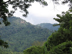
nice long ride up into saraburi via ban na. first time up that way (jed khot nature center/grok e-dok waterfall). once up into this area the rolling terrain was very nice for riding, though the roads are a bit rough in some places (had to carry the bike over some dirt road for 50m & across a really messed up bridge). so watch out on some of the downhills. also stock up on water, once you make the turn into this area there's nothing there but a Royal Thai Forestry station (though they were pretty friendly when i went past). there are a few small shops in the village where you make the turn.

chunk of metal shredded my front tire on way to khlong 12 just past the lum lukka hospital (ultimately caused me to pussy out on the way into the grok-e-dok area, turned around a bit earlier than i had planned). it blew out so hard it showered me with water & mud, scared the bejeebers out of me. replaced the tube & kept going. the tire finally gave out about 20km from home (though it did eat thru all 3 of my spare tubes before giving up the ghost).

as usual the forerunner GPS swallowed the 1st 20km of ride--i guess i need to ride faster or get a better GPS (the forerunner has a limit of 3000 points & collects them every 9 seconds come hell or highwater).

in case you didn't know already, there's a bike shop in ban na (just to the left of the 33 & 3051 intersection as you come into town). its mainly a mountain bike shop but they have a few road bike tubes, etc. that might help in a pinch. nice folks.


View Larger Map

From bike rides